Subject: ArmyJoe's Perpetual Picture Thread Sat May 24, 2014 6:36 pm
Note - This thread was originally crossposted from advrider.com. Original post date - 05-20-2013 --------------------------------------------------------------------------------------------------------------
The Road goes ever on and on Down from the door where it began. Now far ahead the Road has gone, And I must follow, if I can, Pursuing it with weary feet, Until it joins some larger way, Where many paths and errands meet. And whither then? I cannot say.
- The Fellowship of the Ring by J. R. R. Tolkien
I've always had a bit of wanderlust. Even as a kid, I remember jumping on my bicycle and just exploring. To me, a bike meant freedom and I was lucky to live in an era when nobody had to worry about their kids. Every dirt path became an "Indian trail." Scraps of wood were misappropriated to become clubhouses. But you have to eventually grow up. Right?
I joined the Army right out of High School. My mode of transportation changed, but I still had the wanderlust. I traveled a lot by myself, often taking pictures of my foot in famous places to document my journeys. The best thing about the Army was that it gave me the opportunity to meet a beautiul woman. We got married, settled down, and had children. Damn, kids really put a damper on freedom. But you have to eventually grow up. Right?
Well, it took a long time (20+ years), but we're finally at a point in our lives where we have the time and resources to have some fun again. I re-joined the Army Reserve after an 18-year break in service. The wife bought a motorcycle; I bought two. You know what I discovered? Growing old is mandatory. Growing up is optional.
The Yamaha WR250R is the perfect bike for me. It's like an oversized mountain bike, but will allow me to go anywhere I want to go. I've only been riding on two wheels about 18 months, but I lost 13 months to a deployment in Southwest Asia. In the remaining 5 months, I've managed to put 2600 miles on my little bike. In that time, I've joined other ADVriders on three occasions and had a blast.
Stealing the idea from others, I thought it would be interesting to start a thread so I can track my adventures. Hopefully, I can look back in a few years and see how bad I was or how far I've progressed. If I'm really lucky, my kids will find this thread some day and say, "Damn, dad was cool back in the day."
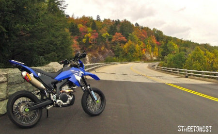
September 3, 2011 - The adventure begins
Last edited by ArmyJoe on Sun Jun 15, 2014 12:55 pm; edited 1 time in total
ArmyJoe
Subject: Re: ArmyJoe's Perpetual Picture Thread Sat May 24, 2014 6:37 pm
October 9, 2011
First group ride. First time on the Interstate. First time on gravel.
Meeting at Iron Pony. (Photo by Solace)
Slabbin' it. (Photo by Solace, edited by me).
Bagging covered bridges. (Photo by buildit)
Waiting on the big bikes
Invisible Monster's 2011 Garage Day. (Photo by buildit)
ArmyJoe
Subject: Re: ArmyJoe's Perpetual Picture Thread Sat May 24, 2014 6:43 pm
November 11, 2011
First solo gravel ride. First bent lever. First time running out of gas.
I had a nice (and eventful) ride down to Zaleski State Forest. The temps were in the 40s, so I wore my snowboarding pants. They worked great. I was pressed for time, so I didn't take a lot of pictures. Unbeknownst to me, the route I planned took me on some nice gravel roads.
The first stop was Hope Furnace to get tag photo location. As you can see from the picture, I bent my clutch lever. Coming down SR 278, I saw a red fox on the side of the road. As I was turning around to get a picture, I dropped it.
From there, I hit the gravel roads and headed over to Moonville tunnel. The new construction tells me they're finally putting in the rail trail to Athens. The water was high, so I couldn't walk across the rocks to the tunnel, so I had to settle for a long distance photo.
Back on the road, I headed past Lookout Rock towards the Mineral tunnel. The route I mapped took me down a closed road. I rode to the end anyway, saw the bridge was blocked with boulders, and backtracked the way I came. Coming at the tunnel from the other direction, I found a short bit of muddy singletrack that took me to the former rail bed. It was pretty cool riding through the old tunnel.
Looking east:
Showing some ADV sticker love:
I was running late, so I hauled ass for home. On the way, I discovered if I'm doing 70-80 MPH, I can get 27 miles from the time the low fuel indicator comes on until I run out of gas. Luckily, the bike is light and I was a mile from a gas station.
Got home just in time to take the wife to Applebees for our Veterans Day meals.
ArmyJoe
Subject: Re: ArmyJoe's Perpetual Picture Thread Sat May 24, 2014 6:46 pm
October 23, 2011
I had my first get-off today while exploring a trail along some rail road tracks. As the saying goes, everything was going along just fine until I ran out of talent. I hit a spot along a slope and one of my tires wandered off the trail or the gravel broke loose. The bike toppled downhill and me with on it. Luckily (and I mean that sarcastically), I didn't fall far because my right leg was pinned between the bike and a log.
After extracting myself and taking pictures, I got the bike upright. It was a struggle since I had to start from below horizontal and I'm glad I didn't have a bigger bike. After getting it up, I walked it back up to the trail while feathering the clutch and then rode out.
Nothing is broke, but there's a little swelling on the left side of my shin (still riding in jeans since I can't afford gear). The timing sucks because I have to drive to Quantico, Virginia next Sunday to run a 3K. I'll spend the rest of the day on the couch with a bag of frozen corn, some boo-boo candy (ibuprofen), and some shit my wife uses after Army Combatives, called dit da jow.
Since I was alone, I took my own pics:
Glad that's finally out of the way.
UPDATE: When I originally posted that, I wasn't aware of the damage I had caused to my leg. As it turned out, I had a bit of nerve damage that caused a 2" by 4" numb spot on the inside of my right calf. It's slowly coming back, but even as of May 2013, it's still not 100%.
ArmyJoe
Subject: Re: ArmyJoe's Perpetual Picture Thread Sat May 24, 2014 6:49 pm
March 23, 2013 - Back from deployment!
First time on unmaintained roads. First failed creek crossing. First successful creek crossing. Fun all around.
Morning meet up. (Photo by Sion)
Failed Creek Crossing. Proved that Garmin Zumo 660's are waterproof. (Photo by Gonzo_Matt)
Learning how to pick my lines. (Photo by Gonzo_Matt)
A short hill climb. (Photo by Gonzo_Matt)
The longest covered bridge in Ohio. (Photo by Sion)
ArmyJoe
Subject: Re: ArmyJoe's Perpetual Picture Thread Sat May 24, 2014 6:52 pm
May 10, 2013
Second solo gravel ride. First stop at Peggy Sue's. First attempt at a log crossing. First thunderstorm.
Failed log crossing. The log crossed the road at an angle and I didn't have enough speed to cary me over.
Somewhere on US-62 in Knox County with the storm clouds rolling in.
Batten down the hatches!
ArmyJoe
Subject: Re: ArmyJoe's Perpetual Picture Thread Sat May 24, 2014 6:53 pm
May 15, 2013 - Perry State Forest
I went offroad for the first time. Perry State Forest is the site of a reclaimed strip mine. In addition to the marked trails. there's a lot of renegade trails that transition between rugged woodland and barren terrain. I did not realize how tiring poor form can be. I have a lot of work to do.
In terms of chronology, the second video should be spliced in at the 11 minute mark of the first one, but it was so epic, I thought it deserved it's own video.
ArmyJoe
Subject: Re: ArmyJoe's Perpetual Picture Thread Sat May 24, 2014 6:55 pm
May 23, 2013
Changed my first tire this morning. It only took about 90 minutes. In reality, it wasn't much harder than doing bicycle tires. The tools and techniques are the same.
I got 3300 miles out of the stock rear tire. The replacement is a Dunlop D606. The front still has some life, so I'm going to leave it for now. I'm kinda frugal.
Before and after:
Using the other tire as a work surface made it easy:
A floor jack helped to hold the tire and get it back into place:
ArmyJoe
Subject: Re: ArmyJoe's Perpetual Picture Thread Sat May 24, 2014 6:57 pm
May 23, 2013
After months of waffling, I finally made a decision in regards to saddle bags. I had really wanted aluminum cases, but could not find them (or make them) for a reasonable price. Instead, I went with the new Monarch Pass Saddle Bags. They have the same capacity as the Expedition Dry Saddle Bags, but at 75% of the cost. The lack of waterproofing is no concern. None of my backpacks are waterproof and I've managed to get by for years with the help of zip-lock bags.
I also mounted a new "top box." It looks like ass, but will let me pack the bulkier items (ie, sleeping bag, tent, etc) without concern.
If everything stays on track, I leave for Deals Gap on Sunday.
ArmyJoe
Subject: Re: ArmyJoe's Perpetual Picture Thread Sat May 24, 2014 7:51 pm
May 23, 2013
Leaving on my first long distance ride on the WR250R. In the minimalist tradition, I'm not carrying a lot of electronics, but I'll be making updates with iPhone. The bulk of the trip report and (hopefully) the best pictures will be posted when I get back.
Planned itinerary:
Sunday - Columbus, Ohio to Cumberland Gap Monday - Cumberland Gap to Deals Gap (includes some TET) Tuesday - Deals Gap area gravel goof-off day Wednesday - Deals Gap to Stone Mountain, NC (via BRP) Thursday - Stone Mountain, NC to Seneca Rocks, WV (via BRP) Friday - Seneca Rocks, WV to Columbus, OH
Should be about 2000 miles.
ArmyJoe
Subject: Re: ArmyJoe's Perpetual Picture Thread Sat May 24, 2014 7:57 pm
Historic Road Tour 2013 (aka Lollygag-apalooza 2013) - Day 1 (May 26, 2013)
I had been planning this trip for months. I was called to Active Duty for deployment from January of 2012 through March of 2013, so I had lots of time to sit with my GPS software, read forums, and plan an epic trip.
As a Reservist, Army regs don't apply to me when I'm not in a duty status, but I figured I'd do the right thing and take a motorcycle refresher course before setting out. I took the MSF Basic Rider Course - 2, which is essentially the Basic Course, minus the classroom time, but on your own bike. I found the WR25R's on-off throttle snatchyness was a pain in the ass for navigating the slow course obstacles, but found it would help me in the long run.
The overall plan was to hit five historic roads: Staunton-Parkersburg Turnpike, Blue Ridge Parkway, Trail of Tears, Tail of the Dragon, and Wilderness Trail / Cumberland Gap. I was originally going to do them in that order, but I failed to account for the Memorial Day holiday. That would put me on the BRP on the holiday, which would have been a nightmare. Instead, I reversed the order and did the loop counter-clockwise. I had reserved camping in every location but Cumberland Gap. Their campsite was on a first-come basis, but I was prepared to stealth camp, if necessary.
I laid out all my gear on Saturday night (May 25th). Considering a few planned gravel routes were up to 10 miles from civilization, I tossed my Army-issued Improved First Aid Kit (IFAK) on the pile. Little did I know this would be the most important decision of my trip. With my gear staged, the intent was to pack in the morning and get on the road by 9 AM. Wishful thinking.
Sunday morning (May 26th), I was up by 8 AM, but was slow to pack and didn't roll out until 10 AM. After a stop a McDonalds for breakfast and update this thread, I realized I forgot my iPhone charging cable. Since this would be my only connection to the outside world, I had to go back and get it. It would be close to 11 AM before I hit the road in earnest.
Though I'm not against riding the WRR on the Interstate, I try to avoid it whenever I can since the air coming off the big rigs can be a pain in the ass. Plus, to paraphrase the old saying, "It's more fun to ride fast on a slow road than to ride slow on a fast road." Either way, I jumped on the Interstate just long enough to get out of Columbus. I soon turned off and headed down US-62 for the log ride across Flatistan, the flat, glaciated portion of Ohio. The frequent stops to get pictures for the Ohio Tag-O-Rama game did not help my schedule.
By 2 PM, I made it to the Ohio River and crossed into Kentucky
On the other side, I drove through an ancient sea.
One of my other hobbies is fossil hunting, so of course I had to stop. My bedrock topology map of Ohio tells me this area most likely from the Ordovician age, 485 to 443 million years old.
I stopped long enough to find a nice brachiopod on a slab.
With a empty tank and empty stomach, I headed into Maysville, Kentucky. One of the best parts of traveling is finding great little places to eat. I try to avoid chains and will ask the locals where they eat. At the gas station, one gentleman said, "Everyone goes to deSha's," so I decided to give it a shot.
I told the waitress, "This is my first time here and I probably my last time. What are you famous for or what do you recommend.?" Unfortunately, my waitress didn't really have a clue and just pointed to the most expensive steak on the menu. I passed on that and went with a cajun grilled chicken breast and grilled vegetables. Not spectacular, but pretty solid.
Getting back on the bike, I headed south through the rolling horse country east of Lexington. Once I got to Winchester, I saw that I was pretty far off my time table. I decided to hit the Interstate to get me back on schedule. It would mean skipping Fort Boonesborough State Park, but would allow me to make a quick stop in Lexington to buy some Lara bars for breakfast and emergency rations.
Ninety minutes later, I got off on US-25E and headed towards Cumberland Gap. Close to sunset, I headed through the tunnel and came out in Tennessee.
A mile later, I was in Virginia.
I pulled into the campground and was relieved to find it almost empty. I found a campsite, set up my tent by headlight, and then drove back to the ranger station to self-register and pay my $12.
It was about 10 PM by this time, and I was pretty hungry. It being a Sunday night, I knew I might have trouble finding someplace open, but I gave it a shot. Heading back up the tunnel into Middlesboro, Kentucky, I tried chasing down a few places on my GPS, but I either couldn't find them or found them closed. I eventually found a little dive called Waffle King.
It looked like a Waffle Hut, so I figured the food would be plain and cheap. I was right, but the sausage, gravy, and biscuits were pretty damn good.
I headed back to camp and saw the only moon I'd see for the entire trip.
Day 1 was complete. My GPS odometer showed 349 miles for the day, already my longest ride ever on two wheels.
Here's a rough trip route for the day: http://goo.gl/maps/jhPZF
ArmyJoe
Subject: Re: ArmyJoe's Perpetual Picture Thread Sat May 24, 2014 8:00 pm
Day 2 (May 27th)
My first and only night sleeping on the ground was pretty miserable. No matter how I tossed and turned, I could not find a comfortable position. When my alarm went off at 7 AM, I turned it off and went back to sleep. I woke around 8:30 AM, ate a few Lara bars, and broke camp. I pulled out around 9:30 AM.
The night before, I was looking at the park map and saw an interesting road. Pinacle Road was a twisty, 3-mile lane that looked to offer some spectacular views of the gap. I headed back up the tunnel to Kentucky and headed up the road. It was a great warmup for the twisties to come and I was right about the view.
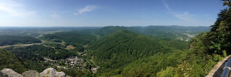
Fern Lake from the overlook trail.
A panorama of the pass. Cumberland Gap, Tennessee is on the left, the gap in the center, and Middlesboro, Kentucky at the right. It doesn't look like much, but the alternating ridgelines and valleys of the Appalachians were such a barrier to western travel, it wasn't until Daniel Boone cut the Wilderness Trail through the Cumberland Gap that several hundred thousand settlers were able to move into Tennessee, Kentucky, and the Ohio Valley.
After a quick trip down the hill, I rode through the tunnel for the fifth time and then headed east on the Wilderness Road towards Kingsport, Tennessee. The road offered great views from the Cumberland Mountains. This is Powell Mountain at 2319 feet.
I eventually made it down to Hampton, Tennessee and the Trans Eastern Trail.
I crossed into North Carolina somewhere in the boonies, so there was no state sign. I'll have to get my photo on the way out.
At one point, the TET route had construction and I was forced to detour. At a really shitty intersection (uphill and pointed towards oncoming traffic), I went to put my foot down and found only air. Thankfully, this would be my only drop of the trip because lifting it with gear really sucks.
Running behind, I leap-frogged sections of the TET to catch up on time. Random photos from the trip.
I rode through Maggie Valley and was surprised by the lack of traffic lights. I stopped at the west end of the valley for a photo.
Heading west on US-19, I approached the intersection with the Blue Ridge Parkway and saw this really weird deer sign. I didn't think much of it, but damn near locked up the brakes when I saw this. I never knew they had elk in North Carolina.
I blew through Cherokee, shaking my head at the stereotypical commercialization of Native American culture. Everything was closed, but I wondered if Cherokees or the white man owned and operated all those shops. A little further down the road, I stopped in Bryson City for a sandwich and some beer, then made the final push to Kickstand Lodge. I rolled in at 9 PM and really didn't want to sleep on the ground. I asked what they had available with a bed. The bunkhouse sleeps six, but nobody was in there. Four only $4 more than the tent fee, I took it. After dropping my gear, I took my food and drink over to the campfire to chat with the other riders.
I know Mo! (on the left)
351 miles for the day (beating my previous record by 2 miles) and 700 miles for the trip. Here's a rough trip route for the day: http://goo.gl/maps/03t1p
ArmyJoe
Subject: Re: ArmyJoe's Perpetual Picture Thread Sun May 25, 2014 9:39 am
Day 3 (May 28th)
I had set my alarm for 8:30 AM, but woke up at 8. It's amazing how well six hours of sleep feels on a real bed. I had three beers the night before and woke with a slight headache and the shits. I'm a beer snob and tried a local brew, Highland Brewing Company's Oatmeal Porter. Allegedly very good, but didn't agree with my system.
The bunkhouse.
After a quick breakfast of ham and eggs, stopped for a quick picture and decided on my route for the day.
Using this as a guide, I had a 400-mile adventure loop plotted out, but I knew I couldn't do it all in one day. I purposefully designed in smaller loops that can be bypassed, if needed.
I immediately cut out the Clingman's Dome, Cades Cove, Parson's Branch loop. Instead, I headed straight up NC-28 to the Dragon. The ride up was perfect. I didn't see a single vehicle in my lane for the whole 22-mile ride.
Fontana Lake from NC-28
I got to the store and slammed a Mt Dew to deal with the headache, then took some pictures.
I then headed out to the Dragon. For my first (and only) run on two wheels, I didn't try to break any speed records, but didn't want to lead a parade either. As memory serves, I only pulled over twice to let faster traffic by. From parking lot to parking lot, I ran the 11.7 miles in just under 23 minutes, for a moving average 30.5 MPH.
From killboy.com
I headed over to the other side of the river to get to the gravel, hitting Citco Road, Cold Spring Road, and Doublecamp Creek Road. The last two, shown below, make a nice 15-mile loop. The first 8 miles are all uphill, then a 2-mile downhill, then a 5-mile flat run along a creek.
From there I jumped on the Cherohala Skyway for a few miles and headed for Bald River Falls.
There I met Dave (aka TWTourist on advrider.com) who happen to be friends with two guys I had met at Kickstand Lodge the night before. All three of them were up from Texas.
I was getting hungry by this point, so I headed into Tellico Plains. First stop was to Tellico Motorcycle Outfitters to get a Powerlet / Cigarette Lighter splitter for my Powerlet socket. This would allow me to use my USB power supply to charge phone and cameras while riding.
After that, I headed over to Tellico Grains for a quick bite to eat. Looking at my GPS, I saw that I'd have just enough time to do the Little Snowbird - Beaver Creek connector and Tatham Gap Road (aka Trail of Tears) before it got dark. I hauled ass back down the Skyway, stopping long enough for your standard "rider gazing towards the horizon" shot.
I then turned off on the 28-mile route I planned for Little Snowbird - Beaver Creek Road.
It's a great route, but it got confusing at the end of Little Snowbird. It turns out you have to go down Porterfield Gap Road, even though it's marked "Private." I tried standing for most of the route down Beaver Creek and found that I prefer it to sitting, but the handlebars are just a touch too low.
Stopping in Andrews only long enough to get gas, I headed back though town to Tatham Gap Road.
What the fuck...
Nooooooooooooooooo...
Turns out the road was closed three months ago. I considered going around the gate, but a quick Google search attributed the closing to heavy rains in January making unsafe road conditions.
Well, my day was done. I rode up to Robbinsville and then over to Kickstand Lodge. On the way, I passed over the AT
I got in before sunset for the only time this trip. Only 230 miles for the day and 930 for the trip.
ArmyJoe
Subject: Re: ArmyJoe's Perpetual Picture Thread Sun May 25, 2014 9:59 am
Day 4 (May 29, 2013)
Up at 9 AM, it was time to start the 3-day journey home. The first day was a short trip up the Blue Ridge Parkway and a few stops, but my plans fell apart. The first stop was supposed to be Wheels Through Time, but they're not open on Wednesdays. The second stop was supposed to be Grandfather Mountain, but I didn't have enough time. More on that later.
By the time I was packed and ready to head out, it was about 10 AM. The Texas ADV guys were heading up the BRP too, so I hung out a few minutes more waiting for them.
We got underway about 10:30, but ran into trouble almost immediately. Leon (aka FocusFrenzy on advrider.com) sprung a coolant leak and headed back to Kickstand Lodge. Since I had a GPS, Jeff (aka TossingLead on advrider.com) and Dave (aka TWTourist) followed me to Cherokee. After gassing-up, Dave decided to head back to Kickstand Lodge to help Leon with repairs. Dave was heading to Virginia Beach, so we headed up the BRP.
Dave (aka TWTourist)
Jeff (aka TossingLead)
The Parkway offered spectacular views, but the tunnels sucked. I was wearing sunglasses, so I was damn-near blind going through them. All I could do was just aim for the middle of the road and pray a cyclist wasn't in there with me.
We made one stop mid-morning at the high point.
And stopped at Asheville for lunch. By this time, the three and a half days on the saddle were beginning to take their toll and my ass was pretty sore. Dave's GPS was telling him he was heading further away from his goal, so we said our goodbyes and he prepared to head east on I-40. I went in search of WalMart to buy an ATV seat cover and an air mattress. Almost an hour later I was back on the road, but not feeling better. I was glad for the seat length so I could move around, but I still couldn't get comfortable. I found myself making extra stops to get off the bike.
At the Craggy Gardens overlook, I met Damian from Argentina, who was touring on his BMW. Unfortunately, he had broken down, but some other riders had his rescue underway.
Views from the overlook.
Getting back on the bike, I only made it 50 miles to the Linville Falls Visitor Center before I had to stop again. Nature called and as I'm sitting there trying to figure out why I'm so sore, I look down and it finally hit me. It was my underwear. When I ride, I usually wear moisture-wiking compression shorts. On all my previous, single-day trips, I never had them on long enough to have a problem. But now, the seam of the shorts was creating wear marks and irritation. Not having anything else to change into, I just decided to go commando. What a difference. Within 30 minutes, all the pain was gone and I rode the remainder of the trip without any issues.
Maybe next time, Grandfather Mountain.
18 miles out, I see my goal for the evening, Stone Mountain State Park, North Carolina.
Another view from 9 miles out.
I got to the park around 8 PM and found out they close at 9. And they really do mean closed. They lock the gates and campers can't leave until 8 AM. I asked the guy at the campground check-in for a place to eat. He mentioned a general store just outside the park. Good enough.
The wood rats were out. The other day at Kickstand Lodge, I had mentioned to someone how improbable it was to hit a deer. "Like a bullet hitting a bullet," I said. Soon enough I would eat my words.
Stone Mountain General Store
I had a 5/8th of a large pizza and something called Cheerwine. Turns out it was a cherry cola, which I don't care for, but I drank it anyway.
Heading back to camp, I once again set up in the dark, but glad to have an air mattress. I chugged two Porters from a few nights ago, hoping it wouldn't have the same effect, took a shower, and went to bed.
I woke at 7:30 AM with the hopes of hitting the road early since today would be my longest ride of the trip. Not bloody likely. After an extended trip to the bathroom (damn beer again) and packing, I was ready to head out around 8:30 AM.
Wanting a better photo of Stone Mountain, I rode around the park, but could not find a clear view. This annoyed the hell out of me because I had been here before and seem to recall parking right at the base of the slab. For those that have never heard of it, Stone Mountain is a popular rock climbing destination. It picked up the nickname, "Home of the Running Belay," because of its routes. With a lot of space between bolts, the belayer (person holding the rope) would sometimes have to run away from route to remove slack before the climber hits the gound. Oh, well. No photo and 30 minutes wasted.
Heading back up to the Parkway, I passed over the Eastern Continental Divide.
Not wanting to stop for pictures and not wanting to take anymore video (I already have 2.5 hours to go through), I set my GoPro to take pictures every 30 seconds. Here's a few of the interesting ones.
Towards the end of the BRP, I took time to explore Fire Road 162, a well known jeep trail.
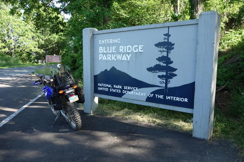
Before long I was at the end of the Parkway. Since there was no "leaving" sign, I bagged the "entering" sign at mile marker 0.
From there, I took I-64 to Staunton. Most people heading to West Virginia and Ohio know that US-250 is a great motorcycle route that snakes over the parallel hills of the Appalachians. Fewer would know that this is part of the Staunton and Parkersburg Turnpike, a road laid out in the first half of the 1800s to connect tidewater Virginia to the Ohio River valley. Fewer yet know that several sections of the Turnpike were bypassed by US routes and still exist today as gravel roads. My plan was to travel the original route from Staunton to Parkersburg. Finding the original route wasn't too horribly difficult. With street names like "Old Parkersburg Turnpike" and "Old Pike Road," it was easy to plan the route and find 26 miles of gravel.
The classic hill and valley topology of the central Appalachians.
At the VA-WV border, I got a two-fer.
Back out on the bypassed gravel, I found a Civil War-era Union camp. Given the strategic importance of the road, there would be several skirmishes along its length.
I also stopped at Travellers Repose, the first stage coach stop west of the mountains.
Leaving the Turnpike for now, I headed north on WV-28 for the Seneca Shadows campground.
The sun was quickly setting in my mirrors.
At 8:45 PM, the little bike that could turned 5. I marveled at how 40% of my total miles had been put on in the last five days.
Making the last push into Seneca, I was about 7 miles out when my luck ran out (or I got really lucky, depending on your point of view). I was riding along at about 50 MPH, when all of a sudden a deer jumped out at me from the right side and passed in front. I honestly don't think I even had time to react. Before I knew it, my bike was doing violent oscillations down the road. I knew it didn't hit it broadside, so I must have clipped her back legs. Soon enough, the bike settled down as a result of the gyroscopic force of the wheels and I kept it upright. As soon as I was able to, I turned around and went looking for it. I didn't see anything, so I turned around and went back north. On the way, I noticed I was having no physical reaction at all. No adrenaline dump, no fast breathing, nothing. What did this mean? Was it Army training or years of World of Warcraft that prepared me to deal with stressful situations?
Rolling into Seneca it got kind of spooky. There was a heavy fog and a lot of leaves and small twigs down. I would find out later an isolated thunderstorm cell had moved through the valley. I pulled into town about 9 PM only to find they rolled up the sidewalks at 8. I was lucky to find a few guys parking a school bus in the parking lot of a motel. I asked if they knew any places to eat and one of them gave me a gallon ziploc of crackers, chicken salad, and juice boxes. Oh, well. At least I wouldn't starve.
I headed over to the campground to find the attendant station empty. As I pulled out my iPhone to confirm my campsite, another motorcyclist pulled up next to me. He asked where I was camping and then led me to the spot. Turns out three kids from Richmond were camped there, so he led me to an open site next to his. We made our introductions. Patrick Hough was a Quality Specialist, junior hockey league (NAHL) scout, and racer. I pulled out my phone to call the wife and found I had no service. Pat immediately offered the use of his van so I could go down the road until I hit coverage. Awesome guy! I drove for six miles without finding a signal. Pulling into a business to turn around, I checked for a wifi signal on a whim. Lo and behold, they had an open network. I sent a text to my wife, but figured she'd not see it until morning, so I posted a message on Facebook asking friends to give her a call. Having done my due diligence, I turned around and went back to camp.
I set up my tent and then ran into Pat coming back from the camp with the three kids. Turns out he also bummed food from the same guys earlier, but he had hot dogs. We went back to their camp and cooked a few more hot dogs. Free food never tasted so good!
About midnight I said my goodbyes and went to sleep.
390 miles for the day (new record) and 1618 for the trip.
Getting up at 8:30 AM, I packed up and thanked Pat for his hospitality.
My tent
Tent with rainfly removed to show air mattress and mummy bag.
Pat was camera shy, but here's his CBR929RR
Heading into Seneca Rocks, I stopped by Harper's Old Country Store. Catering to campers and rock jocks, this place has just about everything.
Next door is The Gendarme Climbing Shop and Seneca Rocks Climbing School. My wife and I were students at the school about 18 years ago. She and I summited Seneca Rocks twice, once with an instructor from the school and once by ourselves.
Seneca Rocks, rising 900 feet off the valley floor, is the highest point east of the Mississippi that can only be reached by climbing.
From there, I headed 48 miles down WV-28 to the National Radio Astronomy Observatory at Green Bank.
Since my Army job involves satellite communications, I have a thing for large parabolic antennas. The Green Bank Telescope (on the left) is 100 meters (328 feet) in diameter. I'd love to get a closer view.
Heading back up WV-28, I continued where I left off on the Staunton-Parkersburg Turnpike. After nine miles of pavement, it was time to hit some gravel and explore Cheat Summit Fort.
Coming back down, I found some puddles and the 100-year old Cheat bridge.
Back on asphalt, I got to Beverly, West Virginia and stopped at the local visitor center. This building served as the Union headquarters for most of the Civil War.
Inside, I asked for information about bypassed portions of the Turnpike, but they weren't able to tell me anything I didn't already know. On the way out, I asked for a recommendation for somewhere to eat. I was told that Mama's Kitchen was a mile down the road on the right.
Finally, someone hit one out of the park. This place rocked! I had the special: beans, home fries, ham, and cornbread. It was delicious and more than I could eat. I'll definitely stop here again.
Heading due west, I left the US-250 and took the original route over the hill. At the top, half way through a 4-mile gravel road, I found a marker for the Battle of Rich Mountain.
Coming down off the hill, it was back onto the paved portion of the bypassed route, heading for Buckhannon, West Virginia. That's when the shit hit the fan. Here's the report I sent to my Commander:
Quote :
At 1409 on 31 May 2013, I was riding a motorcycle west on Old Elkins Road (aka, Buckhannon Pike) in West Virginia, on the last leg of a 6-day, 2000-mile solo trip. As I entered the unincorporated community of Ellamore, I came upon a wrecked motorcycle in the middle of the road (Google Maps address of 10754 Old Elkins Road, Buckhannon, WV). No EMS was present, so I pulled over to survey the scene.
On the right side of the road, a distraught woman was on the phone, standing next to a pickup truck. On the left side of the road, the rider was sitting upright in the east-bound lane, but his right leg was at an odd angle that indicated a fracture. I parked my motorcycle and went to offer assistance. As soon I started to approach and ask if he needed help, I heard him say, "She ripped my leg off." I immediately saw that he had a very large pool of blood under his leg and he was attempting to stem the flow using a belt as a tourniquet just above his knee. He moved slightly and it was obvious his tibia and fibula were shattered and very little was holding his leg together.
I told him I had an Army-issued tourniquet and asked if he wanted me to apply it. He said yes, so I went back to get my Improved First Aid Kit (IFAK) from my saddlebag. Not knowing the extent of his injuries and not wanting to cause further harm, I placed my tourniquet directly above his. After it was on, other bystanders and I helped him to lie down on his back (treat for shock) and continued to talk to him to reassure him and to monitor his consciousness. During our conversation, I learned his name was Thomas Morris, that he was a Platoon Sergeant in Vietnam, and that he had been awarded the Bronze Star Medal with "V" Device.
EMS was still not on-scene by 1416 and a crowd was forming. I took a moment to clear the immediate area of crash debris and called 911 to get an update. The operator told me ambulances were being dispatched from Buckhannon (11 miles west) and Elkins (17 miles east). I informed her of the extent of the injury and told her I applied a tourniquet. She asked for my name and told me EMS would be there shortly.
After another five minutes, the first ambulance arrived. I introduced myself, pointed out the tourniquet, and told them it had been on about 10 minutes. I was asked to support the patient’s head and neck as they cut off his boot, sock, and pants leg to examine his injury. Soon after, they applied a neck brace and I helped roll him onto a backboard. He was then loaded into the ambulance and I was told he would be flown by helicopter to Morgantown, 50 miles to the north.
By that point, the patient’s son had arrived. I introduced myself, described what happened, and asked for his contact information. I then went to the remaining EMS and police on-site and asked if they needed me for anything. They did not, so I got on my motorcycle and departed the scene at 1545.
I called the patient’s wife on 1 June 2013 for an update. She told me that he had surgery to pin the leg back together and that he was expected to be in the hospital for at least 4 days. From her description, they are planning for a full recovery.
Oh. My. God. I have never seen so much blood. The puddle under his leg actually had height. I can't say that I saved his life, but without the tourniquet, I was afraid he was going to bleed out. I called his wife a hour ago and she confirmed he'll be in the hospital through the weekend, but today they had him out of bed and sitting in a chair.
I took some pictures, but out of respect for Tom, he does not appear in them. Out of respect for those that are squeamish, you'll need to click the photos to see them.
From the damage to the red truck, it looked like he clipped the front end as she was turning in the opposite direction and crushed his leg between the bike and her bumper.
According to the local TV station, "the driver of the truck was cited for failure to yield to the right of way."
Whew...
Now a few hours behind schedule, I got back on the road and only stopped to take a few more pictures.
The Trans-Allegheny Lunatic Asylum in Weston, one of the largest hand-cut stone masonry building in the US.
Floodwall at Point Park in Parkersburg.
The Parkersburg-Belpre Bridge and my first sight of Ohio
I stopped by Ohio's smallest church (seats 8) to say a small prayer for Tom.
From there, I headed up the entire length of OH-555, aka Triple Nickel. With lots of twisties and rolling hills, some think this is one of Ohio's best roads. But the spot patching and potential for gravel in the turns gets a thumbs down from a lot of riders. I enjoyed it all the same. It was really cool to wave to the Amish (and have them wave back) as they were working in their gardens and fields.
Just as I got to Zanesville at the end of 555, I saw a familiar sight. Anyone that's spent time in the Midwest has seen the evening thunderstorms that roll in.
Checking my weather radar app, I saw I had little time to find cover.
I hauled ass to the nearest McDonalds for dinner and wifi. The rain stopped after an hour and I got back on the road. By now it was about 9:30 PM. The last bit of historic road was National Road, the first improved highway to be built by the federal government, and the straightest damn road in Ohio. Unfortunately, it was too dark to take pictures, so you'll have to settle for a file photo.
Taking a quick detour through downtown Columbus, I took a picture with the city skyline.
From there, it was a short ride home. Pulling in at 11:30 PM, I had 384 miles for the day and 2002 miles for the trip.
MISSION COMPLETE.
ArmyJoe
Subject: Re: ArmyJoe's Perpetual Picture Thread Sat Jun 14, 2014 2:48 pm
(originally posted 06-17-2013)
Ft Gordon, Georgia. My base of operations for the next four months.
ArmyJoe
Subject: Re: ArmyJoe's Perpetual Picture Thread Sat Jun 14, 2014 2:49 pm
(Originally posted 06-20-2013)
It's rained almost all week, so it's been poor conditions for riding. Today was clear and I got out of class early, so I went exploring. Heading out to the training areas, I turned onto the first dirt road I found (after checking for "do not enter" signs).
The roads were sand and pine needles.
Occasional rutted sections added some challenge
My bike got stuck
and took a nap
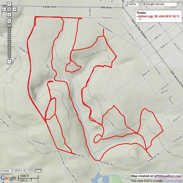
But I managed to string together over 8 miles of dirt.
At it's closest point, this track is only a mile from my room, so I'll definitely be back.
ArmyJoe
Subject: Re: ArmyJoe's Perpetual Picture Thread Sat Jun 14, 2014 2:51 pm
From June 22, 2013, my first Saturday down here.
Most of these are from just across the Savannah River in the Long Cane district of Sumter National Forest, South Carolina. Out riding around, I found a mountain biking area.
Above the [URL="http://en.wikipedia.org/wiki/Fall_line"]fall line[/URL], the sand gives way to this stuff.
A view of the Clarks Hill Dam from the Georgia side.
I see you watching me.
Three shots of the same old house. Normal:
The old timey filter:
And the blue-only filter:
I think I like the last one.
Towards the end of the day, I found a huge mud pit on one of the Forest Service Roads.
Even the bypass looked shitty.
But someone had created a second bypass on the right.
I was debating which way to go when a butterfly landed on my tank bag and pointed to the right. OK, right it is!
It's really nice not riding on sand. I need to get back over there.
I have about two hours of video from last weekend's Long Cane Dual Sport near Abbeville, South Carolina, but no time to turn it into an edited video.
Here's a short one from this weekend. I took a break from studying my CCNP to work on a off-road route about a mile from my room. I was able to string together 5 miles, but I think I can get it up to 7.5 miles with very little overlap. Hopefully by the time I leave in October, I'll be an expert on sand.
Slightly NSFW due to one muffled F-bomb.
Last edited by ArmyJoe on Sat Jun 14, 2014 3:46 pm; edited 2 times in total
ArmyJoe
Subject: Re: ArmyJoe's Perpetual Picture Thread Sat Jun 14, 2014 2:53 pm
(Originally posted 07-04-2013)
I have a 4-day weekend, so I'm heading up the southeast leg of the Trans-Eastern Trail - South (TET-S, aka Southern DS Loop). Over the next few days, I'll be riding through Robbinsville, Tellico Plains, and then dipping back down into Georgia to hit the Suches area. I'm not sure how much is gravel vs. pavement, so I'm not sure how far I'll be able to make it each day. As someone that like to plan trips, this is way out of my comfort zone.
It should be an Adventure.
Aaaaand go!
ArmyJoe
Subject: Re: ArmyJoe's Perpetual Picture Thread Sat Jun 14, 2014 2:57 pm
GTFO 2013, Day 1 - July 4th
I set my alarm for 7 AM, but if it went off, I didn't hear it. I had a long ride planned and this did not bode well. When I woke at 9 AM, I scrambled to get loaded. It was almost 10 by the time I left Fort Gordon. More than once today, I'd scream out at nobody in particular, "I want my two hours back!"
With late start, I chose to bypass the first 60 miles of the route. Instead, I shot straight up Route 28 and would meet the trail just south of Abbeville. It wasn't long before I crossed my first state border of the trip.
A quick side trip to check out the Clarks Hill Lake and Dam.
When I finally regained the TETS, I turned south instead of north. I was in this area two weeks ago for the Long Cane Dual Sport and I wanted to check out the site of an Indian massacre. It wasn't long before I'd hit my first gravel of the trip.
The creeks are running high and dirty.
The Long Cane Massacre burial site. Wow, it just struck me. This happened so long ago, these people were English Colonists.
Most of the morning was a good mix of dirt and asphalt. In addition to weaving back and forth between South Carolina and Georgia, I'd also dodge thunderstorms most of the way. Stopping for lunch in Hartwell, Georgia, I saw this old gas station.
It wasn't long before I reached the mountains, but from here, I rode through almost constant rain.
I was running late and cut out a small portion of trail in order to make it to Kickstand Lodge by 9:30 PM. It was a long day, being on the road almost 12 hours and 311 miles.
Last edited by ArmyJoe on Sat Jun 14, 2014 3:20 pm; edited 1 time in total
ArmyJoe
Subject: Re: ArmyJoe's Perpetual Picture Thread Sat Jun 14, 2014 3:13 pm
GTFO 2013, Day 2 - July 5, 2013
I was prepared to camp when I arrived at Kickstand Lodge the night before, but with the rain, I figured there would be a few cancellations. I asked Mo, the owner, if there was room in the bunkhouse. She said there were two guys already in there, but said I could ask them if I could crash in there too. Since they were also tent campers that upgraded, they had no problem letting me grab one of the six beds.
When I got inside, the place looked like a yard sale with all the wet motorcycle gear on the floor and hanging from the walls.
KP and Paul were visiting from Missouri and weren't about to let the rain spoil their weekend. Thanks guys!
I woke about 8:30 AM. After packing my gear and getting dressed, it was about 10 AM. I dropped $30 in the donation can to cover my lodging, last night's dinner, and a beer. I made a stop in Robbinsville at the slowest McDonalds ever for a bite to eat and wifi and then it was back on the road.
Before long, I was at the start of the Cherohala Skyway.
But what do we say to the Cherohala? "Not today!" I headed off down one of the many gravel roads in the area.
I found for the most part, forest roads are great for travel, but they suck for views. Rather than bore you with more photos of my bike parked in the middle of yet another gravel road, here's some other photos.
Around lunch time, I arrived in Tellico Plains. Having been there before, I went straight to Tellico Grains for lunch. Pulling up outside, I wasn't surprised to see two other inmates were here as well.
Inside I met Ken and Terry (SemperFi71 on advrider). They're lucky enough to live in the area.
On the way out, I saw that Ken had a cover on his Wolfman tank bag. I didn't get one with mine, but he said he got it at Tellico Motorcycle Outfitters.
I went across the street to meet Mike, but he didn't have any covers in stock. While I had his attention, I asked him about the Witt Road creek crossings. With all the rain, I was kind of concerned. I don't have a good track record when it comes to water and the last thing I wanted to do was drown the bike in the middle of nowhere. Mike assured me there hadn't been a lot of rain in the area. He also warned me about the fourth crossing and its exposed bedrock. He advised me to either go left or right and to definitely stay out of the middle, especially if the bedrock was underwater. He even pulled up a fail video from advrider.com to reinforce the point. Armed with this knowledge, I thanked him for his time and headed out.
As I came to each creek, I dismounted and scouted the terrain. The fourth crossing looked kind of iffy. As I feared, the water was a little high. The left spot had a deep hole that I thought I could clear. The right spot looked low, but the ripple of the current made it difficult to see the bottom. I was planning to go left, but changed my mind at the last minute. You can see the results for yourself.
Note - Video is PG-13 due to the use of one F-word.
With a new-found sense of confidence, I headed off down the road to my unknown camping destination. Along the way, I stopped to move this guy to the other side of the road.
More random photos:
About 6 PM, I stopped for gas and Subway. Looking at the GPS, I started looking at the TET waypoints for a camping area. Not far from me was someplace labeled "GA Hick." I found the name amusing, so I made that my goal for the night.
I got there about 7 PM, just as a storm was rolling in. I quickly got set up, listened to some music on my GPS / MP3 player, and ate my dinner.
I also checked the weather radar. It looks like it'll be a wet night.
Checking my GPS, I see I had 461 miles for the trip, 150 for the day, and loads of elevation changes.
ArmyJoe
Subject: Re: ArmyJoe's Perpetual Picture Thread Sat Jun 14, 2014 3:23 pm
GTFO 2013, Day 3 - July 6, 2013
I woke at 7:30 AM to the sound of screaming children. Ahh, the sounds of public campgrounds. I checked the weather radar and it looked like most of the storms would stay to the west, but I was in for a bit of early morning rain.
I alternated between staring out the door of the tent and drifing off to sleep.
About 9 AM the rain passed and I got up and started packing. Sleeping next to the stream was nice because I didn't need my sound machine app to make white noise.
Around 10 AM, I finally pulled out of the campsite. I think I'm sensing a trend with these 10 o'clock departures.
After a quick stop in Chatsworth, Georgia, for McDonalds, I was back on the road. After regaining the paved portion of the TET, I came across a downed tree on CCC Camp Road. I don't remember the storm being that bad, but I slept pretty soundly the night before. Since nobody was around I called it into 911 so they could get someone out to cut it up.
The forest roads were sloppy from all the rain and I rode a lot slower than I really wanted to. After a few hours, I saw a sign I recognized.
I had hoped I'd come by here. I've hiked most of the New Jersey sections of the Appalachian Trail as a Scout and always wanted to see where it started.
I was surprised to find that the official start of the trail is about a mile from the parking lot, up hill, and to the south. After getting there, hikers then have to turn around and head back the way they came from.
I was debating making the hike to the start when a couple came down the other way. I asked if there was a view and they said there normally was, but that cloud cover created limited visibility. About that time, the wind started picking up, heralding of another storm cell. That sealed it for me. Springer Mountain would have to wait for another day. I wolfed down a few Lara bars in lieu of lunch and headed east. Ah, more rain.
About 30 minutes from Helen, Georgia, I passed Helton Creek Falls. I could hear the water over the sound of my engine, so I parked and walked down the trail to take a look. The place looked half-destroyed because the Forest Service cut down all the hemlock trees (and left them to rot) because of an infestation of the woolly adelgid, an invasive insect from Asia. The falls themselves were beautiful due to the volume of water.
As I was taking my pictures, a couple asked me to take their picture. I said OK and they hand me an iPad. /groan. I set up a perfect "rule of thirds" horizontal shot with the falls in the background. After they look at it, they ask if I can take another one vertical. /facepalm. I almost said no. iDevices are ruining photography and video. It's even got it's own term: Vertical video syndrome.
They offered to take my picture, but I politely refused. Heading back out on the road, I was surprised by not one, but two creek crossings. All that water that made the falls look beautiful was now looking pretty ugly to me. The water was not only swift and deep, but the ripples obscured the bottom. Faced with back tracking or going forward, I chose the latter.
As you can hear, I was pretty stoked to make it across.
Back on the two-lane road, I stopped to check out one of the few views I've seen on the trip.
I rolled into Helen, a faux-Bavarian alpine town, about 6 PM and decided to call it a day. I checked into the Helendorf River Inn in the heart of downtown and went to my room to clean up. After doing laundry and spreading my tent and gear about the room, I went to explore the town.
As I said earlier, it's exactly what I expected in a tourist trap of a mountain town. I was a bit self-conscious of my attire, but nobody but me seemed to care. I ate at Hogpen Gap Grill. The jagerschnitzel was delicious.
After that, I went looking for a place to sit and enjoy a few beers. I didn't catch the name of this place (it's behind Paul's), but it was crowded, had a live band, served large beers, and had a view of the Chattahoochee River.
I went back to my room about midnight. My tally for the day was 139 miles and 596 miles for the entire trip.
ArmyJoe
Subject: Re: ArmyJoe's Perpetual Picture Thread Sat Jun 14, 2014 3:35 pm
GTFO 2013, Day 4 - July 7, 2013
I woke about 9 AM and started packing. I stepped out onto the balcony to get my tent and noticed the Chattahoochee River was running pretty fast and nobody was tubing.
I checked the weather radar and saw most of the rain was going to stay to the west.
I said "Tschüß" to my hotel and rolled out about 10 AM. (See, it is a pattern).
I stopped just outside of town to gas up and eat a honey bun and then headed up Chattahoochee River Road. About five miles in, I hit a snag.
Just past the closed section, I was treated to a waterfall from one of the many tributary creeks.
After 14-miles of asphalt, I found myself back on dirt. I was surprised by the steep, rutted road and it wasn't until the very end that I realized I was on one of the sections that offered a bypass. Picking my way slowly up the road, I was doing fine until I bashed the bike on a rock. It stalled me, so I quickly looked for damage. I still had my shifter, so I figured I was good to go. I started it up, unvoluntarily slid back a few feet, picked a new line, and was back in progress. I was rewarded with a rutted descent and then three water crossings.
Damn.
Oh, shit.
You've got to be fucking kidding me. Nobody said shit about crossing a damn river.
I scouted the first two and then cleared them, but the Tallulah River stopped me dead in my tracks. Standing there, I had no way of judging how deep the water was or where the opposite exit was. I tried calling to some waders on the other side, but they couldn't hear me over the sound of the water. I had two obvious choices: go back over the two creeks and up the rutted hill (and there was no guarantee I wouldn't drop my bike in those creeks) or go forward. As the man said, "That which does not kill us makes us stronger," so I decided to go for it. But I really needed to find out where to come out on the other side. If there weren't people there, I would have waded across. I figured, what the hell, my feet are going to get wet anyway. Instead, I tried to go down the bank just a bit and try yelling across one more time. Although they couldn't hear me, when I made a zooming motion with my hand, a lady pointed to the bank behind a tree. I figured that was it and gave it a go.
[youtube]U7aQ32wFOH8[youtube]
Clearing that was my last hurdle. I had a little more asphalt, one more forest road to climb and descend, a little more asphalt, and then I was back in Rabun Gap. Programming Gate 1 of Ft Gordon into my GPS, I saw I had a three hour trip back. Turning the bike south down US-23 (which also goes through my home town), I didn't get far before my stomach started growling. Passing Tomlin's BBQ, I doubled back to try it out. I thought the pork was a little dry, but the vinegar BBQ sauce more than made up for it.
Not long after that, I made a quick stop at Tallulah Gorge. One of these days I'll have to make the trip back up here so I can see the gorge up close.
From there, it was almost a straight shot down to Augusta. As I got about 10 miles from post, I saw a rainbow from a passing thunderstorm cell.
Was this finally an omen of good things to come? Not bloody likely. Rolling up to the gate, I got a rude reminder as to why I'm in the Reserve and not still Active Duty.
The gate had only one lane open and traffic was pretty backed up. Rather than put cones down blocking the other lanes, the guards left them open. Drivers would shoot up the closed lanes and then force their way in at the last minute. Knowing I'm a "soft target" on a motorcycle, I tried to hug the rear bumper of the car in front of me so nobody could get in. My strategy backfired. When the car ahead of me got to the gate, I noticed the passenger talking with the guard and pointing my way. They moved on and I moved up. As soon as I got to the gate, the guard stepped off the curb like he was going to start something. He barks, "Is that GoPro on?" Really, dude? I understand OPSEC as much as the next guy, but was there a need to go full Hooah on a TRADOC post? Hell, anyone with a driver's license can get in. If someone was really interested in casing the joint, all they'd have to do is drive in themselves.
I told him the camera was off (it was) and showed him my ID. As he handed it back to me he said the car ahead of me reported that I "don't know how to drive that thing" and that I "almost hit them several times." He waited for an answer, but I just shrugged. My God, I don't know how people can put up with this shit on a daily basis. I'd go nuts or get busted down to Private.
I got back on post about 7 PM and took one last photo at Signal Towers, the home of the US Army Signal Center of Excellence.
The GPS says I have 233 miles for the day and 829 for the trip. It also show the descent from the mountains down to the coastal plain.
All in all it was a great trip. I'd do it again, even with all the rain. The creek crossings really built my confidence and I identified that I need to get faster on downhill turns. Best of all, I didn't drop the bike a single time.
The only thing I do differently is have waterproof boots (I've already ordered Alpinestars Scout WP boots) and maybe a few extra parts in case something really bad happened. I have a 4-day weekend for Labor Day. Who knows, maybe I'll do the same route in the other direction. For now it's...
MISSION COMPLETE
ArmyJoe
Subject: Re: ArmyJoe's Perpetual Picture Thread Sat Jun 14, 2014 3:38 pm
You saw the sights, now hear the sounds. Each 60-second video brings you a bit of nature. Pick your happy place.