Subject: Re: DualSportMaps.com - New Mapping Site For Riders Tue Nov 29, 2011 1:06 pm
Hey Jager. It just got cold here yesterday. Warm > Cold!
I am very sensitive to this topic of ground-truthed versus unknown sourced tracks. I avoided this very feature for a long time based on this very reason. Ultimately I found the software less useful to me like this. I use the software to do a lot of planning as well. A GPX source doesn't mean the track is good. An active log doesn't mean it was legal. Ultimately we must rely on our own best judgement and the kindness of posters. What I did do was set Blank Maps to be PRIVATE by default. In fact you have to create the map and then go back and UPDATE it to make it public. It's not a lot, but I hope it is enough to keep garbage down to a minimum.
We can reevaluate if things start to go down the wrong path.
Jäger Admin
Subject: Re: DualSportMaps.com - New Mapping Site For Riders Tue Nov 29, 2011 2:59 pm
I'm following you on this.
I was just about to nudge you and ask for the ability to do planning of trips within DSM, although if truth be told I do most trip planning within ArcGIS as I have access to the most recent mapping in this area through that. Most people don't have that ability, but if I didn't have it I would appreciate the ability to do planning within DSM. So I like this new extension of capabilities a lot.
I'm also aware that we can't trust everyone to be faithful in uploading tracks that are rideable/legal/exist or whatever - or to remove the track when it ceases to be usable. My faith in my fellow man is not particularly great at the best of times, so I'm probably skeptical of tracks more than most to begin with, and therefore unlikely to get burned.
The idea of making it Private is probably a pretty good compromise that I hadn't thought of.
craftycoder
Subject: New website update. Sat Dec 03, 2011 12:14 am
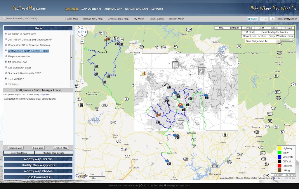
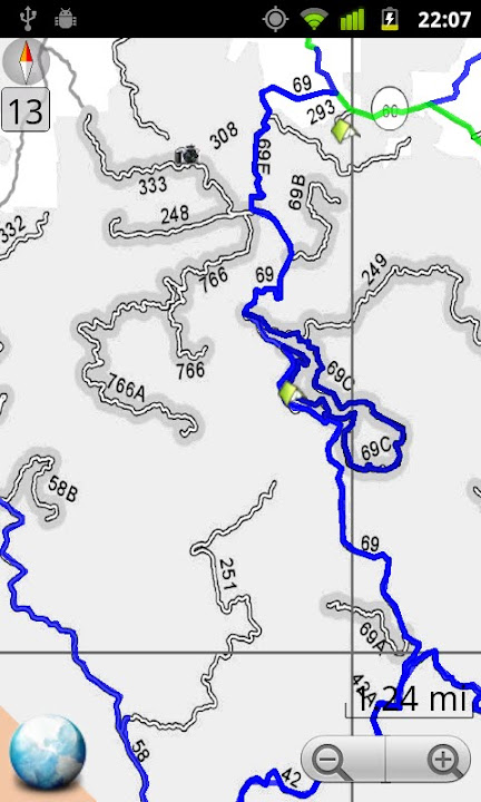
The website has been updated with a cool new feature. You can now upload georeferenced raster maps to overlay on top of the base maps but below the tracks. This is an MVUM of the local National Forest. In the second image you can see that you can adjust the overlay transparency. The third photo shows the overlay in the Android app. This is a future feature not quite yet ready.
ramz
Subject: Re: DualSportMaps.com - New Mapping Site For Riders Sat Dec 03, 2011 2:06 am
Quote :
You can now upload georeferenced raster maps to overlay on top of the base maps but below the tracks. This is an MVUM of the local National Forest.
How do you prepare the MVUM? The ones I have are pdf files and I can convert them to jpg, but I haven't a clue how to make them into georeferenced raster maps.
craftycoder
Subject: Re: DualSportMaps.com - New Mapping Site For Riders Sat Dec 03, 2011 2:09 am
ramz wrote:
Quote :
You can now upload georeferenced raster maps to overlay on top of the base maps but below the tracks. This is an MVUM of the local National Forest.
How do you prepare the MVUM? The ones I have are pdf files and I can convert them to jpg, but I haven't a clue how to make them into georeferenced raster maps.
I use GIMP to extract the JPG from the PDF.
There is a video linked on the Map Overlay page that shows how to geocode them in Google Earth. I'll be making a full help video in the coming weeks. This is all still pretty bleeding edge stuff, but one user has already figured it out and uploaded some maps. It's a good start.
Crim Guest
Subject: Add images to others routes? Sat Dec 03, 2011 9:22 pm
Hey Crafty, is it possible to upload/attach images to other user's routes?
I rode your "Windy Gap - Rock Creek 2010-05-31" tracks today and have a few pictures of the trail that I could add. Also is it possible to post comments about the tracks? If not, I think both of these would be useful additions.
PS -- Perhaps I'm just a wimp, but that one section of tibbs OHV on your tracks I would consider nearly impassible via dualsport....pretty intense.
craftycoder
Subject: Re: DualSportMaps.com - New Mapping Site For Riders Sat Dec 03, 2011 9:24 pm
Crim wrote:
Hey Crafty, is it possible to upload/attach images to other user's routes?
I rode your "Windy Gap - Rock Creek 2010-05-31" tracks today and have a few pictures of the trail that I could add. Also is it possible to post comments about the tracks? If not, I think both of these would be useful additions.
PS -- Perhaps I'm just a wimp, but that one section of tibbs OHV on your tracks I would consider nearly impassible via dualsport....pretty intense.
The 1200GS took a beating there, but I was on a 250 that day :)
You can upload photos to a blank map and they will appear on my map so just make a Blank Map and name it Crim's Photos and pin you photos to the map in it.
There is a comments section on the left side as well. I've got you covered!
craftycoder
Subject: website update Tue Dec 27, 2011 11:55 pm
I updated the website, implementing a user's idea about linking and embedding maps with either the default view or the linkers current view. Below is a map embedded with a very high zoom and a specific map selected. You can also specify overlays during this process.
kriehl
Subject: Dual Sport Maps Tue Jan 10, 2012 1:52 pm
Hello,
Nice work. I thought I posted a reply earlier this week but I must have messed up.
Some things I run into when making my maps you have made much easier. I usually use Google maps then output those tracks using takitwithme.com. On my phone I use Oruxmaps to follow the tracks and Everytrail to record and link my photos to post online.
Some of things I would like to be able to do....and you may have already done this but I have not found it yet.
1) be able to output good bitmaps just around the tracks. Oruxmaps does this, but usually you have to make a bunch of rectangles around the tracks in order to reduce the overall file size. Not sure if there is a better method of creating these offline maps, just in case there is a track that is blocked and a reroute needs to be done visually. It would be really nice to even brake these files up per track, because "usually" you have cell service at fuel stops or end of day stops and can download the next offline map for the upcoming section.
2) be able to break up a track by miles. It is nice to have a way to find out how many miles you are from the start of a track so you can break it up for a goal or a fuel stop. I like to make long tracks and then go back and find my fuel or detours to find fuel.
I have not loaded the droid version on my phone yet. I was looking for more information to see if you are doing anything like the everytrail option.
Oh I noticed on a large track I was doing my brower timed out several times. I was trying to use the edit and move some points closer to my actual track. I found a way around this but using the cut option and moving the points. As long as I moved them instead of clicking it worked the same. Also is there a way to cut from two points so you can remove the wrong turns and backtracks? Kind of like you do the follow roads, click on start and end and remove what is in between. This way when you glue it back together it is a shorter fill and you don't have to move points to match the actual tracks.....hope this makes sense.
Keith
craftycoder
Subject: Re: DualSportMaps.com - New Mapping Site For Riders Tue Jan 10, 2012 2:03 pm
kriehl wrote:
1) be able to output good bitmaps just around the tracks. Oruxmaps does this, but usually you have to make a bunch of rectangles around the tracks in order to reduce the overall file size. Not sure if there is a better method of creating these offline maps, just in case there is a track that is blocked and a reroute needs to be done visually. It would be really nice to even brake these files up per track, because "usually" you have cell service at fuel stops or end of day stops and can download the next offline map for the upcoming section.
Do you mean print them when you say output?
kriehl wrote:
2) be able to break up a track by miles. It is nice to have a way to find out how many miles you are from the start of a track so you can break it up for a goal or a fuel stop. I like to make long tracks and then go back and find my fuel or detours to find fuel.
Let me think about this. I've got some ideas to try out.
kriehl wrote:
I have not loaded the droid version on my phone yet. I was looking for more information to see if you are doing anything like the everytrail option.
I'm not sure what "the everytrail option" means.
kriehl wrote:
Oh I noticed on a large track I was doing my brower timed out several times. I was trying to use the edit and move some points closer to my actual track. I found a way around this but using the cut option and moving the points. As long as I moved them instead of clicking it worked the same. Also is there a way to cut from two points so you can remove the wrong turns and backtracks? Kind of like you do the follow roads, click on start and end and remove what is in between. This way when you glue it back together it is a shorter fill and you don't have to move points to match the actual tracks.....hope this makes sense.
Depending on how powerful your computer is, you can run into issues with tracks with many thousands of points. I suggest breaking them up into smaller pieces (with the cut track tool) to make them easier to work with. There is a join track tool (the glue bottle button) that allows you to join tracks. You can only join the start of a track to the end of another though, so you may need to use the reverse track button to before you can join a track. Practice with a few short tracks to get the hang of it.
kriehl
Subject: Re: DualSportMaps.com - New Mapping Site For Riders Thu Jan 12, 2012 5:24 pm
craftycoder wrote:
kriehl wrote:
1) be able to output good bitmaps just around the tracks. Oruxmaps does this, but usually you have to make a bunch of rectangles around the tracks in order to reduce the overall file size. Not sure if there is a better method of creating these offline maps, just in case there is a track that is blocked and a reroute needs to be done visually. It would be really nice to even brake these files up per track, because "usually" you have cell service at fuel stops or end of day stops and can download the next offline map for the upcoming section.
Do you mean print them when you say output?
No I meant use them as offline overlays when no cell service is available. I just want them to be small so I can fit more on the phone card. In other programs you have to make large rectangles and you get a bunch of wasted area that you don't need. I will down load the app for the droid and check out what you have already.
kriehl wrote:
2) be able to break up a track by miles. It is nice to have a way to find out how many miles you are from the start of a track so you can break it up for a goal or a fuel stop. I like to make long tracks and then go back and find my fuel or detours to find fuel.
Let me think about this. I've got some ideas to try out.
kriehl wrote:
I have not loaded the droid version on my phone yet. I was looking for more information to see if you are doing anything like the everytrail option.
I'm not sure what "the everytrail option" means.
Everytrail is a gps tracking program that you can track your current path and take photos along the way and add a story. www.everytrail.com when you up load your gpx file to the server it uploads all the photos too and they are posted along the path exactly where you took the photo. Kind of nice so you don't have to go back manually put the photos in the correct spot.
kriehl wrote:
Oh I noticed on a large track I was doing my brower timed out several times. I was trying to use the edit and move some points closer to my actual track. I found a way around this but using the cut option and moving the points. As long as I moved them instead of clicking it worked the same. Also is there a way to cut from two points so you can remove the wrong turns and backtracks? Kind of like you do the follow roads, click on start and end and remove what is in between. This way when you glue it back together it is a shorter fill and you don't have to move points to match the actual tracks.....hope this makes sense.
Depending on how powerful your computer is, you can run into issues with tracks with many thousands of points. I suggest breaking them up into smaller pieces (with the cut track tool) to make them easier to work with. There is a join track tool (the glue bottle button) that allows you to join tracks. You can only join the start of a track to the end of another though, so you may need to use the reverse track button to before you can join a track. Practice with a few short tracks to get the hang of it.
I have been having a good time playing with this program so far. It looks like the server is a little slow and I have to wait some time after making changes to see my whole map again. Even if I hit the refresh on the browser it takes a little while to get all the updates. I noticed last night it was even worse and in the mornings it seemed to work pretty fast. Maybe more users in the evening.
A couple more suggestions.
It would be nice if you can import, copy or just see way points around the area you are making maps. I was working on a new map and I noticed someone had already marked fuel stops, camping and hotels in an area I will be riding. It is hard to go get them one at a time. It would be nice to bring all of them over and start deleting the ones that are not important to your new track.
An undo button would be great? Might be overload on the server though keeping track of changes. I deleted a complicated trail that was not on marked roads and had to go back find a copy on my computer to upload again.
Can you add points when you do the make new track. That way if the follow roads button does not pick the correct roads you can add more points? Same with the edit button I know you can move the points but could you add points?
Oh I imported a gpx file and the tracks came across as routes, is there anyway to move routes and tracks back and fourth or is there a good reason to have routes vs tracks in your program.
and I noticed none of my way points came across when I did the create new map and uploaded my GPX file?
Sincerely,
Keith
craftycoder
Subject: Re: DualSportMaps.com - New Mapping Site For Riders Thu Jan 12, 2012 6:13 pm
I'd like to know how to reproduce the slowness you are describing. The servers are fast. I'm guessing the performance issues are on the client, but I'd like to get a detailed procedure from you so I can figure out the issue you are trying to describe.
Your suggestion to make copying waypoints easier has been on my mind. I'll work on that soon.
I'm not doing another level of UNDO, too complicated. Instead I require you to "save" the track changes (if you don't save them they are undone, try it out on a test map) and I make you confirm your track deletions. That should be enough I think...
I'm not sure what you mean by "add points when you do the make new track". All it does is add new points. If the snap to road feature doesn't go the way you want, answer NO to the confirm box, and use the Edit Track tool to add another point to help inform the snap wizard and try again. You may have to do it a few times before its right, but that process works well and is the expected process.
Changing tracks to routes and back is simple. Click on the colored square next to the track name (like you are changing the track color) and use the "Is Route" check box.
Some waypoint types do not come across if there are too many of them. This was done purposefully because some GPX files are cluttered with useless route waypoints for example. Details here... http://www.advrider.com/forums/showpost.php?p=14544650&postcount=33
kriehl wrote:
I have been having a good time playing with this program so far. It looks like the server is a little slow and I have to wait some time after making changes to see my whole map again. Even if I hit the refresh on the browser it takes a little while to get all the updates. I noticed last night it was even worse and in the mornings it seemed to work pretty fast. Maybe more users in the evening.
A couple more suggestions.
It would be nice if you can import, copy or just see way points around the area you are making maps. I was working on a new map and I noticed someone had already marked fuel stops, camping and hotels in an area I will be riding. It is hard to go get them one at a time. It would be nice to bring all of them over and start deleting the ones that are not important to your new track.
An undo button would be great? Might be overload on the server though keeping track of changes. I deleted a complicated trail that was not on marked roads and had to go back find a copy on my computer to upload again.
Can you add points when you do the make new track. That way if the follow roads button does not pick the correct roads you can add more points? Same with the edit button I know you can move the points but could you add points?
Oh I imported a gpx file and the tracks came across as routes, is there anyway to move routes and tracks back and fourth or is there a good reason to have routes vs tracks in your program.
and I noticed none of my way points came across when I did the create new map and uploaded my GPX file?
Sincerely,
Keith
here
craftycoder
Subject: Re: DualSportMaps.com - New Mapping Site For Riders Sat Jan 14, 2012 10:53 pm
the website will be down for an hour or two on Monday. I am doing a hardware upgrade. I'm not sure what time yet.
craftycoder
Subject: New help videos. Wed Jan 18, 2012 1:55 pm
I posted a bunch of new help videos created by a helpful user Strega. Thank you VERY much bud. You can see the list of videos by click on the 4th icon from the right below.
DragonNester
Subject: Re: DualSportMaps.com - New Mapping Site For Riders Sun Jan 22, 2012 6:16 pm
I decided to contribute a few tracks, way points and a route to your site. I hope folks that come to the lair of the Dragon (east TN/western NC) will take the opportunity to run some of these. My hope is to help facilitate a better experience for visitors and local explorers alike.
I know I always appreciate a heads up on where to ride, with GPS support, when visiting different places.
Thanks CC for creating this unique service and best of luck!
craftycoder
Subject: Re: DualSportMaps.com - New Mapping Site For Riders Sun Jan 22, 2012 6:22 pm
Great, thats not too far from me.
DragonNester wrote:
I decided to contribute a few tracks, way points and a route to your site. I hope folks that come to the lair of the Dragon (east TN/western NC) will take the opportunity to run some of these. My hope is to help facilitate a better experience for visitors and local explorers alike.
I know I always appreciate a heads up on where to ride, with GPS support, when visiting different places.
Thanks CC for creating this unique service and best of luck!
FosTerHM Guest
Subject: Suggestions... Sat Mar 03, 2012 6:53 pm
I think that we need to ability to comment and post ratings for routes on dualsportmaps.com and the mobile app. Also, I would like a button on the mobile app to "start tracking", "pause", and "record/ end route". Perhaps there is already a way to do this simply that I am unaware of but I didn't see it if it exists. Thanks for the app and the hard work! Love it!!!
craftycoder
Subject: Re: DualSportMaps.com - New Mapping Site For Riders Sat Mar 03, 2012 6:57 pm
There is a comment area on the left. The app is always tracking when the map is up. I figure it easier to clean up tracks later than to recreate track points after the fact. You can write the current points to a GPX file and start a new one at any time by through Settings=>Monitoring=>Save Current Track
FosTerHM wrote:
I think that we need to ability to comment and post ratings for routes on dualsportmaps.com and the mobile app. Also, I would like a button on the mobile app to "start tracking", "pause", and "record/ end route". Perhaps there is already a way to do this simply that I am unaware of but I didn't see it if it exists. Thanks for the app and the hard work! Love it!!!
Overkill Guest
Subject: OSM integration Wed Mar 21, 2012 12:51 pm
I have started moving all of my maps over into OpenStreetMap. I think it's structured appropriately to hold all the data we need for these types of tasks.
In addition to the standard way of labelling "ways" for trail type, surface type, seasonal/time based openings and closings, I am also proposing a grading system for difficulty. On ways marked highway=trail, I am adding a tag dirtbike:scale=1-10. This mirrors the way the mountain bike folks are handling things.
Given Dual Sport Maps' focus on, well, Dual Sport Maps, and your clear ability to code this kind of stuff, do you have any plans at supporting OSM by making or building in support for dirt-bike specific (and thus dual sport) trail attributes?
The community can get the data into OSM, but we need a viewer to make it useful. :-)
craftycoder
Subject: Re: DualSportMaps.com - New Mapping Site For Riders Wed Mar 21, 2012 1:35 pm
There is an OSM map layer (Mapnik) available. If they are rendering trail attributes then you would see them on my site. Are you requesting that I create a dual sport specific OSM rendering service? I'd love to do that, but I'm going to need a few more grand a month in storage and electricity costs not to mention a LOT more hardware. Currently the site is 2 servers, one that is very beefy and the other a run of the mill quad core 4GB ram webserver. It is backed by an EMC² harddisk array and in a very nice datacenter. All this is already what any reasonable person would describe as expensive. Pick any number you think it reasonable, multiply it by ten and you are low.
A new OSM rendering service for dual sport would be bleeping awesome and I'd be all over that, but I need funding and a lot. I avoid charging for the website as that is the basic convention on the internet. Yesterday I got >145000 hits. It was a big day, but not abnormal. The site is taking on a life of its own but like Seymore's plant (in Little Shop of Horrors) it's starting to be a bit of a moral dilemma how to keep feeding the beast.
Great idea though!
Overkill wrote:
I have started moving all of my maps over into OpenStreetMap. I think it's structured appropriately to hold all the data we need for these types of tasks.
In addition to the standard way of labelling "ways" for trail type, surface type, seasonal/time based openings and closings, I am also proposing a grading system for difficulty. On ways marked highway=trail, I am adding a tag dirtbike:scale=1-10. This mirrors the way the mountain bike folks are handling things.
Given Dual Sport Maps' focus on, well, Dual Sport Maps, and your clear ability to code this kind of stuff, do you have any plans at supporting OSM by making or building in support for dirt-bike specific (and thus dual sport) trail attributes?
The community can get the data into OSM, but we need a viewer to make it useful. :-)
[TASF]Overkill
Subject: Re: DualSportMaps.com - New Mapping Site For Riders Tue Mar 27, 2012 12:15 pm
I guess what I'm really interested in is unification of data sets. OSM wants to capture all roads/paths/trails, including the subset that DualSportMaps mappers are interested in. The thing that has prevented me from getting my trails involved in a website (I manage an unwieldy Google Earth file of Virginia trails) is that I want it to be as generally useful in as many places as possible. OSM has adoption and support by many developers on several different platforms. I see OSM as keenly interested in ALL data in great detail, while DualSportMaps is storing specifically dual sport trail data in great detail.
What I'm wondering is if you have any plans / interest in transitioning the DSM data storage into OSM, as it seems well suited to the task. That would largely free you of data management tasks, and instead free up time for tweaking on the interface TO that data, as well as fiddling with possible custom route planning algorithms and other exciting stuff. (Well, exciting to me)
What I envision is a complete OSM map set with roads, trails, hiking paths, etc... managed by data geeks like myself. What is missing (And Dual Sport Maps is kind of established to become this) would be a viewer for that information.
Viewing: -Filters for what kind of vehicle is being ridden. Dirt bike? Street legal dual sport? Trails would be shown or hidden based on their highway=* attribute or other custom tags. ("Dirtbike=yes", "atv=no", etc) -Filters for what kind of track surface. Only show dirt and gravel if desired. Based on existing surface=* attributes. -Colorize tracks (using current color scheme on DSM) based on difficulty. I currently tag difficulty on a 1-10 scale using "dirtbike:scale=*" tag. -Somehow denote trail closings, based on OSM's "date_on=MMDD" and "date_off="MMDD" tags
Routing: -Route based on desired difficulty range. R1200GS's aren't going to go on a skill "8" trail. -Route based on expected time of travel, taking trail closings into effect -Give precedence to certain features where possible, such as avoiding pavement, taking any trail with a skill 3 or greater that presents itself.
Basically... I'd like to see DSM rather than being just a record of other peoples' travels, I'd like to see it employed as a planning engine based on OSM data. Like in Google Maps where you can check "Avoid Highways", on DS bikes we want the option to check "Have Adventure" even en route to the most mundane of places. OSM is ideal for "What is there" and how are these things connected, which includes a significant part of what DSM is going for. DSM would then stand out as a way of creating routes based on input, or viewing other peoples' suggested routes over those OSM roads.
I'm not expecting much in the way of traction (Deathwings on red clay) here... After all you have a vision for "your baby". But I'm hoping my nebulous ramblings might spark something.
Quote :
There is an OSM map layer (Mapnik) available. If they are rendering trail attributes then you would see them on my site.
They do not, and they're more of a frame work for rendering maps. Someone would have to mold that into (Or create their own) "something" specifically geared toward representing DS maps.
Quote :
Are you requesting that I create a dual sport specific OSM rendering service?
I can't request anything. :-) I can just share wishes and hopefully inspiration. Heh. But sort of. I'd like to see DSM make use of its strengths and the "dual sport" focus... Which to me is less about duplicating a subset of the the work of OSM (possibly instead contributing to its data) and more about sharing community suggestions.
Quote :
I'd love to do that, but I'm going to need a few more grand a month in storage and electricity costs not to mention a LOT more hardware. Currently the site is 2 servers, one that is very beefy and the other a run of the mill quad core 4GB ram webserver. It is backed by an EMC² harddisk array and in a very nice datacenter. All this is already what any reasonable person would describe as expensive. Pick any number you think it reasonable, multiply it by ten and you are low.
Which makes me wonder if utilizing OSM for the data back end would cut back on any of that at all! I have a lot of questions about the backend of DSM... But perhaps another thread. I'm a server engineer and we're 99% virtualized in our DCs... Curiosity always gets me. I don't suppose a little donated web space would do you any good?
Quote :
A new OSM rendering service for dual sport would be bleeping awesome and I'd be all over that, but I need funding and a lot. I avoid charging for the website as that is the basic convention on the internet.
It seems to be HUGE out west... but so far it hasn't been particularly useful for me out here. I'm solely looking for a long-lived place to store my data for others. :-) I guess at the very least, the ability to import ways from OSM and automatically read in the various attributes that DSM wuold be interested in would allow me to contribute to both projects by starting at one place. You certainly have a regional critical mass right now. But OSM is global. :-)
Quote :
Yesterday I got >145000 hits. It was a big day, but not abnormal.
This is why I'm interested in DSM... It is positioned to be "the one"... Domain name makes sense, top google search hit for what is no doubt a common term... And dual sporting is kind of taking off!
Quote :
The site is taking on a life of its own but like Seymore's plant (in Little Shop of Horrors) it's starting to be a bit of a moral dilemma how to keep feeding the beast.
I'm surprised that there seem to be no ads at all. I would expect with that many hits, some non-intrusive ads here and there would generate some revenue, but perhaps upset the "gimme it free!" community.
Woo. Rants.
I would pay for a system. Data (which I think should be free and open). Web interface. Mobile interface. Offline mobile interface. I've tried a few things, but nothing has really struck me yet. Trimble Outdoors came close.... But the system being closed sucks.
[TASF]Overkill
Subject: Re: DualSportMaps.com - New Mapping Site For Riders Tue Mar 27, 2012 12:22 pm
My basic "wah":
These 2 simple tracks contain the minimal information to label them and colorize them for difficulty. http://osm.org/go/ZT4Piv8J--
This trail contains enough information to label, colorize for difficulty, and show seasonal closings. http://osm.org/go/ZTvPKX3x--
I am putting all of the GWNF MVUM trails I've recorded GPS tracks for into OSM (and will now start recording trails in segments based on difficulty, rather than assigning one difficulty to an entire trail), but no interface currently exists to turn that data into information useful for dual sport riders.
craftycoder
Subject: Re: DualSportMaps.com - New Mapping Site For Riders Tue Mar 27, 2012 12:55 pm
Those tracks show up in DSM on the Mapnik tile set. http://www.dualsportmaps.com/?link=103370
I like where you are going with this. While I absolutely support you posting your tracks to OSM, I am a little uncomfortable with the idea of ME posting your tracks to OSM. I do not want to "litter" their database with bad data and a some of my data is either repetitive, old, or illegal. This is just the nature of public access databases. I am certain OSM has the same problem. I just don't want to be a wholesale contributor to the problem. This may be a shortsighted point of view though...
The hardware I have put together for this project is for performance. Using OSM for data storage would defeat my performance goals because of latency among other things and I would be at their mercy for access to "my" data. I like that I keep my data local. What would be cool is the ability to "promote" a track to OSM after it has been vetted, so to speak. It would then show up in their database and eventually in the MAPNIK tiles.
I wonder what it would be like to add OSM's vector track data to my search system though. I could grab their data based on some search criteria and then render tracks just like I render the tracks currently. It would be slower to respond, but that ok as some data would already be on the screen.
In either event, I would be very interested in getting your VA data into my system. Maintaining the data in DSM is pretty convenient...
Would you mind sending me the OSM search criteria to get the "Adventure" track data as you envision it? I'll see about roughing out a system to download that data on request and render as vector data rather than raster info. That offers the option to export that data to GPX for people going for a ride. It also limits the CPU requirements because I am not trying to render the entire globe as a raster.
[TASF]Overkill wrote:
My basic "wah":
These 2 simple tracks contain the minimal information to label them and colorize them for difficulty. http://osm.org/go/ZT4Piv8J--
This trail contains enough information to label, colorize for difficulty, and show seasonal closings. http://osm.org/go/ZTvPKX3x--
I am putting all of the GWNF MVUM trails I've recorded GPS tracks for into OSM (and will now start recording trails in segments based on difficulty, rather than assigning one difficulty to an entire trail), but no interface currently exists to turn that data into information useful for dual sport riders.
craftycoder
Subject: Re: DualSportMaps.com - New Mapping Site For Riders Tue Mar 27, 2012 1:14 pm
As is typical of my experience with OSM, every search API I try to hit from the wiki never responds to web requests in a useful way. Please hook me up with a helloworld for querying that data along with a server that is actually online and accepting requests.
[TASF]Overkill
Subject: Re: DualSportMaps.com - New Mapping Site For Riders Tue Mar 27, 2012 2:27 pm
Quote :
Those tracks show up in DSM on the Mapnik tile set. http://www.dualsportmaps.com/?link=103370
Right, but they're formatted generically and minimally since forestry roads are of minimal interest to most map users (I.e., drivers). In the DSM map world, these little grey dashed lines are probably the bulk of the interesting data!
Quote :
I am a little uncomfortable with the idea of ME posting your tracks to OSM. I do not want to "litter" their database with bad data and a some of my data is either repetitive, old, or illegal.
I wasn't really even thinking of a two-way communication between the sites... But now that you mention it... GPX files can be uploaded to OSM for tracing. Theoretically (If you wanted to make a contribution to OSM, not necessarily to further the value-add of DSM) you could export your tracks as annotated GPX files to OSM as GPS traces. They wouldn't be shown in OSM, but would be treated as "raw" data that mappers could use to set attributes / correct routes on existing ways as well as put in new ones that haven't been mapped yet.
Quote :
The hardware I have put together for this project is for performance. Using OSM for data storage would defeat my performance goals because of latency among other things and I would be at their mercy for access to "my" data. I like that I keep my data local.
I think the entire OSM data set is about 20GB compressed. Obviously that's a lot of data... There are diff releases and tile sets that would make that less painful to update, but you could store it locally and keep it synched. I just don't know if that would save you anything over your current setup. Probably not given the size! Bummer.
Quote :
What would be cool is the ability to "promote" a track to OSM after it has been vetted, so to speak. It would then show up in their database and eventually in the MAPNIK tiles.
I'm not sure that would be possible (except using the "GPS traces" mentioned above). You'd have to do some kind of collision detection / node merging to make sure you weren't "contributing" a new way where there are existing ways... and to make sure that the uploaded way is connected to other ways appropriately. That kind of nitty gritty work is what the tracers do, but they need good reference data. Unless you built a new editor too. :-)
Quote :
I wonder what it would be like to add OSM's vector track data to my search system though. I could grab their data based on some search criteria and then render tracks just like I render the tracks currently. It would be slower to respond, but that ok as some data would already be on the screen.
And here there is value to me. :-)
Quote :
In either event, I would be very interested in getting your VA data into my system. Maintaining the data in DSM is pretty convenient...
I'll sit time sometime in the next few weeks and see how much more trouble it'd be to put it into both places.
[quote]Would you mind sending me the OSM search criteria to get the "Adventure" track data as you envision it? I'll see about roughing out a system to download that data on request and render as vector data rather than raster info. That offers the option to export that data to GPX for people going for a ride. It also limits the CPU requirements because I am not trying to render the entire globe as a raster.
This is in the JOSM editor, not a viewer... Therefore this is ugly... But using its syntax: All tracks in a given area:
Only ways where "highway=track": For a "trail map" where your only options are trails being on or off, you'd do something like "highway=track AND motor_vehicles!=private AND motor_vehicles!=prohibited AND (surface=dirt OR surface=gravel OR surface=unspecified)".
Here are some of the attributes of "Coon Bridge Trail" show in the advanced view of Potlatch editor. I'm still fiddling with the "right" way to tag some of this stuff, so this is just a basic trail that I've started with. I'm still working on what the proper convention is for some of these attributes, a whole 'nother topic of discussion I'd like your input on.
I'll make a table of all possibly interesting criteria and send your way at some point in the near future.
Sponsored content
Subject: Re: DualSportMaps.com - New Mapping Site For Riders