| | DualSportMaps.com - New Mapping Site For Riders |  |
|
+11pollockk muddyudders Stolenfant [TASF]Overkill DragonNester kriehl Chrispy1200 Arkmage ramz Jäger craftycoder 15 posters |
|
| Author | Message |
|---|
[TASF]Overkill
| | Subject: Re: DualSportMaps.com - New Mapping Site For Riders Wed Apr 04, 2012 11:20 pm | |
| Do you have an existing guideline you would recommend for grading trail conditions on a 1-10 scale? | |
|
| | |
craftycoder

| | Subject: Re: DualSportMaps.com - New Mapping Site For Riders Thu Apr 05, 2012 7:27 am | |
| I have an internal one that I use in the "track wizard" but I ask people to use their best judgement. You never got back to me with an example of how to query the OSM map APIs. I would seriously attempt to include their motorized trail data into dualsportmaps.com, but I could use a little guidance on what server to ask and via what API. As I said above, I've never successfully contacted an OSM API. They are always offline when I attempt to contact them, I assume I just don't know where to find the currently running server list though. I'll help you if you help me. - [TASF]Overkill wrote:
- Do you have an existing guideline you would recommend for grading trail conditions on a 1-10 scale?
| |
|
| | |
[TASF]Overkill
| | Subject: Re: DualSportMaps.com - New Mapping Site For Riders Thu Apr 05, 2012 12:02 pm | |
| You're right about the API's in the Wiki... there have been a lot of changes but few updates to the Wiki bits.
I stumbled on "XAPI" as a way to do what I wanted, but the referenced servers weren't working. Looks like "Overpass" is its own API (Currently in use) and it has an overlay for XAPI. I can't really put together a native Overpass query in XML and fire it off... But in XAPI (Which Overpass will accept), you can do this:
Any tracks in the given bounding box.
http://overpass.osm.rambler.ru/cgi/xapi?way[bbox=-79.358278,37.625678,-79.303346,37.671482][highway=track]
Any dirt roads in the given bounding box that are open to motor vehicles.
http://overpass.osm.rambler.ru/cgi/xapi?way[bbox=-79.358278,37.625678,-79.303346,37.671482][surface=dirt][motor_vehicle=yes]
Any tracks in the given bounding box open to motor vehicles with a dirt bike difficulty assigned.
http://overpass.osm.rambler.ru/cgi/xapi?way[bbox=-79.358278,37.625678,-79.303346,37.671482][highway=track][motor_vehicle=yes][dirtbike:scale=*]
I'm using this documentation:
http://wiki.openstreetmap.org/wiki/Overpass_API#XAPI_Compatibility_Layer
I imagine with XML there's more flexibility.
Note that I have no idea if Overpass is the best way to get info out of OSM. It looks like most of the APIs at this point are people who are mirroring the OSM database and providing their own APIs into that mirror.
Last edited by [TASF]Overkill on Fri Apr 06, 2012 9:23 am; edited 2 times in total | |
|
| | |
[TASF]Overkill
| | Subject: Re: DualSportMaps.com - New Mapping Site For Riders Fri Apr 06, 2012 9:13 am | |
| Ok... corrected a few of them. The XAPI queries that contain an OR can only contain one tag. So that one wasn't working. And I typoed the dirtbike:scale tag in one of them. | |
|
| | |
craftycoder
| | Subject: Re: DualSportMaps.com - New Mapping Site For Riders Fri Apr 06, 2012 9:31 am | |
| - [TASF]Overkill wrote:
- Ok... corrected a few of them. The XAPI queries that contain an OR can only contain one tag. So that one wasn't working. And I typoed the dirtbike:scale tag in one of them.
Thanks, I am getting useful data there now. I'll work on a mechanism for displaying that on the site. | |
|
| | |
[TASF]Overkill
| | Subject: Re: DualSportMaps.com - New Mapping Site For Riders Fri Apr 06, 2012 10:14 am | |
| After looking into Mapnik/OSMARENDER I now see why you have such a beefy farm. I figured map viewers generally worked client side, just sneding the relevant tracks to the client and letting the client handle rendering. Looks like that's not the case... | |
|
| | |
craftycoder
| | Subject: Re: DualSportMaps.com - New Mapping Site For Riders Fri Apr 06, 2012 10:33 am | |
| - [TASF]Overkill wrote:
- After looking into Mapnik/OSMARENDER I now see why you have such a beefy farm. I figured map viewers generally worked client side, just sneding the relevant tracks to the client and letting the client handle rendering. Looks like that's not the case...
its VERY processor intensive to do all those raster projections. The site has a feature to upload raster images that are rectified to the earth. I make tile sets out of them. check out south west georiga for examples... They take about 5 minutes per MB of image. And that is burning the joules, all ahead full captain! | |
|
| | |
[TASF]Overkill
| | Subject: Re: DualSportMaps.com - New Mapping Site For Riders Fri Apr 06, 2012 10:37 am | |
| Would tasks like this be any easier in a world where all browsers handled SVGs or some other vector format natively... and well? | |
|
| | |
craftycoder
| | Subject: Re: DualSportMaps.com - New Mapping Site For Riders Fri Apr 06, 2012 10:41 am | |
| - [TASF]Overkill wrote:
- Would tasks like this be any easier in a world where all browsers handled SVGs or some other vector format natively... and well?
Yes, but in that world we would have magic wands and the ability to use them.  | |
|
| | |
Stolenfant
| | Subject: How do I get a remote? Fri Apr 20, 2012 12:46 am | |
| Loving the app so far. Now, how do I get a remote? I haven't hit enough trees yet. I need another distraction while piloting my WeeStrom through the woods.
Clint | |
|
| | |
craftycoder
| | Subject: Re: DualSportMaps.com - New Mapping Site For Riders Fri Apr 20, 2012 8:09 am | |
| - Stolenfant wrote:
- Loving the app so far. Now, how do I get a remote? I haven't hit enough trees yet. I need another distraction while piloting my WeeStrom through the woods.
Clint The machine shop is working on a less expensive enclosure. Once I can get it to cost $200 I will make them available. Glad you are enjoying that app! | |
|
| | |
[TASF]Overkill
| | Subject: Re: DualSportMaps.com - New Mapping Site For Riders Mon Jun 11, 2012 5:32 pm | |
| Hey Crafty,
Got anything to show off from the OSM angle? I log in to Dual Sport Maps periodically to see if my additions to OSM show up there yet, but I've gotten to the point where I can't remember what I've added to Va. :-)
Also had a good ride yesterday through Virginia FR4008 that took a really nice road ride back... DSM came to mind as a good way to connect those off road segments with the onroad.
I'm thinking of putting together a dual sport ride in the area, linking together the lovely off and on road stuff out here, DSM is gonna be the best way to show that route off, that's for sure. | |
|
| | |
muddyudders
| | Subject: Re: DualSportMaps.com - New Mapping Site For Riders Thu Jun 21, 2012 3:58 am | |
| Crafty,
I deleted a loop titled Great Mix. That had pictures that were shared for a section of road. Any way to retrieve it? | |
|
| | |
Xr Rated
Guest
| | Subject: Zoom Sat Sep 15, 2012 11:17 pm | |
| I have a similar phone/map program that has a wonderful feature. Switch the screen to 2X mode. All the road names and titles become much more readable for these old eyes...
I haven't seen anything like it in this program (yet).
Thanks
|
|
| | |
Xr Rated
Guest
| | Subject: more... Wed Sep 19, 2012 7:06 pm | |
| I found what I was looking for, kind of...
Using pinch to zoom I can find a half-step zoom that is the 2X screen I was referring to. I doubt I could get that while riding. I wish I could lock that in somewhere in the settings so that the 2x would stay on as I use the + and - to zoom the program.
Other than that I'm really liking the app and look forward to more gpx tracks and overlays as time goes on.
Thanks!
|
|
| | |
matteo92
Guest
| | Subject: trouble with Overlays Wed Oct 31, 2012 4:23 pm | |
| Want to start by saying WOW! This is cool software. I don't feel I have the room to complain much or expect much help yet, as I have not bought the software YET. Coming from iphone stuff.. I don't think its possible to buy it until I get my DEFY up and working. I just found out about this software, and ordered (off ebay) a Motorola DEFY, power cord and mount for my Husky TE450 (soon to become a KTM350EXC). I'm going though the tutorial videos, and working with DualSportMaps.com I am particularly interested in the Overlay maps. I've arranged my map in GoogleEarth, saved it as a KMZ. The size is 2.77Mb I go to "upload New Map Overlay" and it shows that the file is going up, then after a pause it gives me the message... 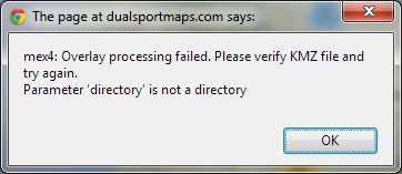 I've tried it different ways, different overlay images, different harddrive locations with no luck. Please advise. Thanks again! |
|
| | |
matteo92
Guest
| | Subject: Remote Case Help Wed Oct 31, 2012 4:27 pm | |
| This project really is of interest to me. I'm a ME and have access to an FDM machine and CNC machines. I can produce free prototypes for you if that would help. I work with SolidWorks. |
|
| | |
pollockk
| | Subject: Jeeps and Tracks Thu Dec 20, 2012 5:47 pm | |
| Your website is the best way i have seen to manage, store and retrieve gps tracks. my hat (and helmet) is off to you!
i am VP of a large jeep club that travels most of the western states. we have a gps library of over 700 tracks documenting our off road trails. Have you ever thought of creating another instance of your software to deal with jeep tracks instead of bike tracks?
i should point out that most of our members are "retired" bikers of one sort or another and have graduated from two wheels to four. we love the outdoors and struggle with an effective way to share track files.
i would appreciate your thoughts and comments - either publicly or privately.
thanks and again, great job on your presentation and features.
| |
|
| | |
Jäger
Admin

| | Subject: Re: DualSportMaps.com - New Mapping Site For Riders Thu Dec 20, 2012 11:30 pm | |
| - pollockk wrote:
- i am VP of a large jeep club that travels most of the western states. we have a gps library of over 700 tracks documenting our off road trails. Have you ever thought of creating another instance of your software to deal with jeep tracks instead of bike tracks?
I won't comment on what Crafty might or might not want to do. But I can tell you that some "dual sport" tracks are useable by a two wheel drive SUV or pickup. Even a car in many instances. A track navigable by a Jeep might well be of interest to a lot of dual sporters to travel on their bike. In my opinion, well documented Jeep tracks to DualSportMaps desired standards would enhance the DSM library, not diminish it. But that's just one DSM user's opinion. | |
|
| | |
pollockk
| | Subject: Re: DualSportMaps.com - New Mapping Site For Riders Fri Dec 21, 2012 1:03 am | |
| I agree with your assessment - we share the roads quite often with bikes. however, there are a lot of two track trails that are not suitable for us. And a lot of our trails are rated very difficult / extreme (4.5 - 5+) and MAY not be suitable for anything but extreme bikes. what would be important to us is to easily distinguish between the Jeep trails and all others.
we are constantly cleaning up our tracks but most are not yet up to your standards. but because we are a club, our members are happy to go with what we have.
all of our tracks are on open, documented trails.
Kim | |
|
| | |
djkelly368

| | Subject: Difference between Google maps and Garmin maps... Fri Jan 04, 2013 2:17 pm | |
| I've been using dualsportmaps.com (absolutely great) to plan a trip that is appx. half off-road and half on-road using drawn tracks only. After roughing out a basic track with the track tool, I snap all or portions of the track I've created to roads. These snapped portions look great when shown on Google maps, but when I load them onto the GPS (Garmin Oregon 450t), the tracks sometimes show up to 100ft off the roads that I had snapped to. I'm sure this is due to slight differences between the Google maps and the Garmin ones, but is there some way I can snap portions of my tracks back to roads (according to the the Garmin maps) using Basecamp or something else? Again, I'm not talking about off-road portions of my tracks, just the ones on roads. I tried to snap them to roads while the OSM maps were showing since they seem a little closer to the Garmin ones, but it seems as though it's still using Google maps to snap. This might not seem like a big issue, but it gets confusing when I'm trying to look at the GPS and figure out what road my track is trying to line up with while riding through a town. I'm using the pre-loaded Garmin topo map on the Oregon. I'm nowhere NEAR my GPS's limit for track points so that's not the issue. Advice anyone?  | |
|
| | |
Jäger
Admin
| | Subject: Re: DualSportMaps.com - New Mapping Site For Riders Sun Jan 06, 2013 12:57 am | |
| I find the DualSportMaps website quite valuable, but I'm not sure why you would use it for planning a ride when Garmin mapping software would be what you would have loaded and be following on the actual trip. It isn't that DSM is inferior to Garmin - the varying choices available for maps to use is something Garmin doesn't offer, for example. The reason is exactly what you have observed: when you lay out your trip using some other map set other than Garmin, you frequently find your planned tracks don't line up with roads when brought in to Garmin's Topo software.
Speaking only for myself, and as somebody that doesn't use the mobile Android version (although I will be looking at that soon) but instead a full-fledged GPS, the greatest value DSM provides is it offers a warehouse where rides can be stored and shared, complete with commentaries, points of interest, pictures, etc.
So if you're using Garmin mapping on the trip, my suggestion would be to use that same map software for doing your trip layout. That way, your tracks WILL line up with the roads. In other words, do your layout in Mapsource or Basecamp - not in DSM. You can always import the end result into DSM to see how it compares to other mapsets available in DSM i.e. USGS, OSM, and then edit in DSM where you might want to before bringing the finished product back to your Garmin.
| |
|
| | |
djkelly368
| | Subject: Re: DualSportMaps.com - New Mapping Site For Riders Mon Jan 07, 2013 11:55 am | |
| Thanks for the reply Jäger! The main reason I was using DualSportMaps was because of the snap track to road feature. I've only briefly used BaseCamp and I'm not aware of a way to snap your track (or sections of it) to a road. There may be a way, but it must have been too obscure for me to figure out while wandering aimlessly through Garmin software that is made for everything but the purpose I'm trying to use it for haha... So I guess my real options are to: a)live with it being off b)learn BaseCamp or make my tracks point by point at tight intervals  c)try to load custom maps from OSM or something similar onto the Oregon I really do like the workflow within DualSportMaps and I like the fact that I can share my tracks with ONLY the other people going on the ride and not the entire world. There are 2 other members on DualSportMaps that are going on the ride and they're helping me with feedback/planning. I have the visibility of my tracks set to only them so as to not lead other riders on a wild goose chase on tracks that have not been verified. I'd like to keep using it to do this in the future, but if BaseCamp is a necessary evil (I'm on a Mac so I don't believe Mapsource will fly) then I guess I'll have to just suck it up. So without dragging this thread off topic with Garmin software questions- much thanks for assistance! | |
|
| | |
Devo
| | Subject: Add base maps? Wed Jan 23, 2013 6:50 pm | |
| Is there a way to add new base maps. We have this E32 map from Cartografia for Baja and would be great if it could be used as a base map. | |
|
| | |
edmondso
Guest
| | Subject: android problems Sat May 25, 2013 1:02 am | |
| I am planning a trip on motorcycle on the Oregon Discovery Route. I would like to use my HTC One X for the navigation with a hand held GPS for backup. When I open the map for my current location, the arrow indicating my position travels off the map, and I am left looking at a map showing my tracks leaving the screen. What am I missing? I have tried everything I can on the settings. Also when I try to do a route to and route from, I says there start point is far from road. Any help would be greatly appreciated. We leave for our trip in 4 weeks, and am hoping to not have to buy another gps. Thanks in advance. |
|
| | |
Sponsored content
| | Subject: Re: DualSportMaps.com - New Mapping Site For Riders | |
| |
|
| | |
| | DualSportMaps.com - New Mapping Site For Riders | |
|